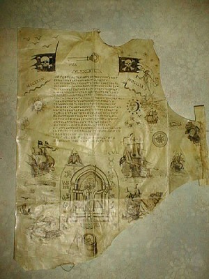
The second “La Buse” cryptogram is a funny old thing: Emmanuel Mezino swears to its authenticity, but I’m really not as convinced as he is – given that a number of key elements (such as the cryptography, the dates, the drawing style, etc) seem jarringly incongruous to my eyes, there seems plenty of good reasons to infer that it is (at best) a later copy and/or an assemblage of earlier pieces, or (at worst) a modern fake.
Here’s Yannick Benaben’s image of it, the earliest that I’ve found on the web:-
And then there’s the cryptogram’s map to consider. Even though La Buse (Olivier Levasseur) ended his piratical career in the Indian Ocean, he seems to have begun it in the Caribbean, so it perhaps shouldn’t be at all surprising that this cryptogram should contain a very high-level map of the Florida / Caribbean area.
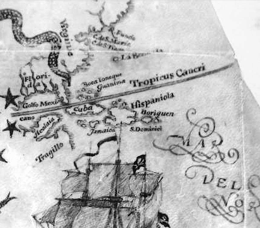
Many names on the map can be identified without difficulty:
* Florida – though because this area became ‘La Louisiane’ (named after Louis XIV of France, of which it was a colony) in 1682, it would seem that this map predates (or appears to predate) 1682.
* Virginie (= “Virginia”)
* Golfo Mexicano (= “Gulf of Mexico”)
* Tragillo (= “Trujillo”)
* Jamaica
* Cuba
* Tropicus Cancri (= “Tropic of Cancer”)
* Hispaniola – it looks to me as though the island of Hispaniola has been miscopied into two halves.
* S. Dominici (= “Santo Domingo”, Hispaniola’s capital city founded by Columbus’ brother Bartholemew in 1496, and also another name for Hispaniola).
* La Bermuda (= “Bermuda”, although on the map this is positioned way too close to the coast)
Curiously, the map has a snake design that wiggles – coincidentally or not, I can’t say – roughly up the path of the Mississippi. It’s far from historically obvious that the Mississippi River was only discovered (by Louis Jolliet and Jacques Marquette, says Wikipedia) in 1673: and hence it is tempting to suspect that this snake design was added simply to cover up a cartographic slip-up by a later forger or hoaxer (i.e. adding the 1673+ Mississippi River to a map supposed to be linked to La Buse, who died in 1730). But that’s just my speculation, please don’t read too much into it. 🙂
The other map labels, though, are slightly less straightforward.
* Boriquen – this is clearly Boriken, the original Taino Indian name for Puerto Rico (although Columbus called it “San Juan Bautista”, i.e. St John the Baptist Island, which is presumably why the capital is called San Juan, and why the island’s motto is “Joannes est nomen eius”).
* Guanima was the original (pre-1520) name of the Bay of Marantzas on the north coast of Cuba, while “Guanahani” was the Taino Indian name for the first island to which Columbus came (the controversy over which island that actually was continues to the present day). And so it seems likely to me that the island on this map marked as “Guanima” was intended to be “Guanahani”, but got mangled in the copying.
* Boca Ioneque – I have no idea what this is. It’s next to “Guanima” and looks as though it is attached to an island, but I’m not sure if that’s helpful or not. All suggestions welcome!
* “Acalaia” / “Alcaldia” (town hall?), apparently on the Yucatan peninsula – though I did manage to work out what this (miscopied and mangled) label was late last year from some 16th century maps, I now cannot find my careful notes on it at all, bah. 🙁
* R. Fuado – I have no idea what this is.
* C. de S. Marie – I have no idea what this is either.
* C. de S ???? – I can’t even read this, let alone guess what it is.
My Thoughts
This map is hugely odd. Not just the mix of languages (Spanish, French, Latin) or the miscopied labels (Guanima, Tragillo) or the suspicious snake tail (covering the Mississippi?) or the miscopied geography (Hispaniola), but the whole thing seems jarring to me. Manu may be convinced, but to my eyes this is all over the place.
But what do you think?
‘Boca Ioneque’ is certainly ‘Lucayoneque,’ an old French name for an island in the Bahama group (more online if you search).
‘Acalaia’ may be either ‘Bacalar’ or ‘Acalan’. According to Wikipedia, Bacalar was sacked by pirates in the seventeenth century, for what that may be worth…
Further up the coast of the US, we seem to have Cap Santa Maria and Cap de San Tiago, and presumably Rio Fundo.
Doesn’t look very genuine to me at all, but what do I know?
It all seems to be leading to (mapping) the ‘Louisiana Purchase”. I’m wondering if it was the same king who ‘owned’ Eastern Canada (Nova Scotia?) (New Brunswick?) French and Indian War (1756 – 1763). (Per my ‘Hammond’s Historical Atlas’).
Acadia.(NE Canada) Cajun ( St. Lawrence River and Mississippi River to its outlet @ New Orleans) .
On the 1747 Ruyter map and the 1696 Danckerts map the territory continues to be called florida, even though on other maps of the period (eg 1732 Moll map) the territory is labelled Louisiana, so I dont believe that the use of the word Florida tells us much about the date.
Cap Santa Maria would probably be the mouth of the Saint Mary River, and if SirHuberts reading of Cap St Tiago is correct this would be the Diego Plains/Fort San Diego area (modern Palm Valley), named after Diego Espinoza settled this area in the early 18th century. Wikipedia says Espinoza arrived in 1703, another source I found says 1730, but both are unreferenced. If this could be resolved, and SirHuberts reading is correct, then a 1730 date would automatically make the map a hoax.
From the geography then, and the river splitting in two this would suggest that the river Fuado is the altamaha, but I have not been able to find anything to link this river to the name on the map.
Re the Hispaniola in two halves, it looks to me more like it is just bloated in the north/south direction from the artists attempts to fit the gulf on the west coast.
I agree with SirHubert’s readings, except that if the names are Spanish, I think C. would stand for Cabo rather than Cap. Perhaps this map shows most of the eastern coast of North America. According to our friend the Internet, the Bay of Fundy, just south of the St. Lawrence River, was at one time called Rio Fundo, and perhaps the name could have been applied to that whole area? An early name for Chesapeake Bay was Bahia de Santa Maria, and it would be easy to refer to the adjacent land, now Cape Charles, as Cabo Santa Maria.
Patagon: just as you say, Florida / Louisiana doesn’t resolve anything. Also: “Cabo St Tiago” seems a very long way north to be part of Florida, so I’d prefer to keep an open mind on that just yet. And the reason I’m quite happy with Hispaniola being miscopied into two halves is that the map shows two reasonably sized islands east of it, when in real life there is only one (Puerto Rico).
Clay: the Bay of Fundy looks like an excellent candidate (I didn’t think to look that far North!), if Wikipedia’s story that 16th century Portuguese fisherman did indeed call it “Rio Fundo” is true. In which case I should add Portuguese to the list of languages referenced in this small polyglot space.
Of course, Wikipedia being what it is, this seems to be an unevidenced claim, so it’s hard to know whether the map we are looking at is a potential source for Wikipedia or a modern hoaxer’s use of the same oft-tainted resource. Definitely an issue that needs resolution. 😉
SirHubert: Lucayoneque is a great find, thanks! Also, I’m pretty sure that Bacalar was exactly what I found before (virtually rooting around the Yucatan peninsula), so thanks for digging that up too!
Both of these seem to support the suggestion that this is a hugely wobbly copy of an older map rather than a consciously wobbly modern fake: we’ve had to work quite hard to get to the underlying geography, and that doesn’t seem to be consistent with an out-and-out hoax.
I’m coming round to the awkward conclusion that what we’re looking at here is a work of unreliable compilation, rather than outright hoaxery. Though I do still think that the last few lines of the cryptogram were added in a separate phase.
For what it’s worth, I suspect that all the source material that the compilation was taken from had been attributed to La Buse and/or other pirates, some correctly and some incorrectly (as is often the way): and that the additional five lines were added to the cryptogram as part of that compilation process.
Nick: I’m sure you’re right that this thing was made by copying details from a number of other old maps. The question is whether this was done in 1700 or, well, let’s say 2003. My own view is that the latter looks much more likely because of how the copying has been done – there is no linguistic consistency at all, and everything seems to have been copied mechanically and without understanding of the geography of the region.
Two specific points:
i) Variant forms of letter ‘a’. The lower-case a’s in ‘Hispaniola’, ‘Florida’ and ‘Golfo Mexicano’ have curved tops, as you’d expect to see in a printed document. Those in ‘Jamaica’, ‘Acalaia’, ‘Boca Ioneque’ and ‘Acalaia’ don’t – they’re normal, cursive, hand-written a’s. Now, that makes sense for someone copying words which they don’t necessarily understand from different sources where the letters happen to have been rendered differently. But would you do that if you were writing words that actually made sense to you? If I gave you a modern outline map of Florida and asked you to write old place names onto it, would you just copy different letter forms across like that, or would you write each word in your own fair hand?
ii) Boca Ionique. How can you end up with that as a mistake for Lucayoneque? I could understand the word being spelled differently by a pirate who had heard it rather than seeing it written, but how on earth can the ‘Boca’ element get in there? It must surely be a copying error, and again made by someone who seems not to have understood what they were copying – hardly convincing for a pirate who is meant to have sailed these waters. Now, whoever produced this map may just have copied an existing mistake (but from where?). But I think it’s much more likely to be the kind of mistake you’d make if you were peering at a slightly grainy jpeg of an old map of the Gulf of Mexico – let’s say in 2003 or thereabouts – and couldn’t read a name properly. You haven’t heard of the Lucayan archipelago, but you’ve heard of Boca Raton in Florida, and the first four letters look a bit like ‘Boca’, so ‘Boca Ionique’ it becomes.
When anyone produces a map, that involves selection: what to include, what to omit, what to emphasize. To me, the greatest amount of time effort appears to have been expended on drawing the rather pretty ship and the swash decoration on ‘Mar del Norte’. Now, for an atlas made in 1700 that would make some sense – these were objects made to sell, and it mattered that they looked attractive as much as being cartographically up to date and accurate. But doesn’t it strike you as odd for a real pirate to spend lots of time drawing a ship and pretty decorative lettering?
well, it looks like an outright hoax to me, for what my subjective opinion is worth. It looks like a film prop. If I wanted to produce something that looked ‘piratey’ (as opposed to piratical) I’d probably come up with something that looked a bit like this. Right down to the peculiar shape.
Begins with ‘H’, rhymes with ‘Jokes.’
Somewhere near “Hispaniola” one should be able to spot the Florida Keys (Cayo Hueso with Marine base) and about 15-20 miles ESE, the “Dry Tortugas”. President Thomas Jefferson turned the larger island into a prison.
I 1-der if La Buse was familiar with that set of islands.
😉
? Lucayoneque = Le Quay [I]Onique
goes to Boca Ionique (cf. Boca Raton).
so ‘Ionique’ was the name of estuary and its town?
Tricia: “Lucayoneque” seems to have had quite a different derivation, as “l’une des grandes îles Lucayes”.
SirHubert: I’m genuinely pleased that we’re looking at the same thing and making broadly the same kind of observations – I thought I was going out on a bit of a limb by suggesting it was some kind of wobbly compilation. But… I don’t honestly see how you reason from what we’re seeing to a hoax. It seems to me that evidence that points to someone aping an existing document making plausible guesses where the text fails – ‘boca’ is Portuguese for mouth, as I understand – would point rather to a genuine document, albeit a hugely confused one.
In the same way that f116v of the Voynich seems to me to be victim of someone’s attempts to preserve it, could this be somehow a victim of a similar – but well-intentioned – process?
Tricia:according to Wikipedia (and therefore definitively inaccurate) the ‘Lucayan’ element is all one word, made up from ‘Lukku-Cairi’, meaning ‘People of the Islands,’ which was how the indigenous population called themselves. The word ‘key’ for ‘island’ does indeed come from the ‘cairi’ part of this, apparently. But I don’t think it can be broken down as you suggest, sorry.
My guess would be that ‘Lucayoneque’ is a French adjectival form from ‘Lucayan’, a bit like ‘Martinique’ for ‘Isle of St Martin’, but others more knowledgeable will tell me if that’s nonsense.
I think ‘Ionique’ is just a misreading by someone who wasn’t familiar with the geography of the area…
Nick: so you are suggesting that this might be a later copy of La Buse’s original and damaged map? And that some of the misspellings like Boca Ionique are the result of someone in relatively recent times trying to reconstruct toponyms from this damaged original?
SirHubert: no, not at all. For a start, I’m not suggesting that this map has anything to do with La Buse; neither am I suggesting that the cryptogram has anything to do with La Buse.
Rather, the position I’m reluctantly coming to is that the whole page is probably a copied compilation of items previously attributed (for each part whether rightly or wrongly I can’t tell) to La Buse, or perhaps (more likely still?) a later copy of a compilation of items previously attributed to La Buse.
And so it seems to me that there are multiple layers of (virtual) codicology to be done; and on an object its owners plainly won’t release to public view, just in case it somehow leads to an astonishing treasure cache of which they get none.
As a result, I’m struggling to really get a feel for when each of the component stages was done.
For instance, the pigpen cipher itself has a long association with Freemasonry, and so there is some reason to suspect a Mason as having originally written the cryptogram down (or at least the first 17 lines of it). However, Freemasonry came to the Indian Ocean several decades after La Buse’s death etc…
Per my “Hammonds Historical Atlas” page H-29, an explorer (“Pineda”) left the island of “Juana” (port of ‘La Habana”) in 1519, and went up the coast of Florida past “La Nouvelle Orleans” and the outlet of the Mississipi River — and continued to follow the Guadalajara coastline and past the Rio Grande outlet to the border of the “Audencia” of Mexico. He apparently did not quite make it to Cortez’s Port of Vera Cruz.
So, I think La Buse’s cryptogram may be more valid than we have expected. ?
beady-eyed wonder 🙂
Sir Hubert –
Just as ‘keys’ has no etymological connection to ‘cay’, and ‘boca’ sounds like an older, Portuguese or Spanish term, replaced by French, I think the La Buse map might be genuine because it reflects the sound of place-names, rather than standard forms.
Tricia: I’m not sure this particular argument holds water – Lucayoneque doesn’t sound at all like Boca Ioneque. In fact, I’d say that the errors on the map part of this cryptogram seem more to do with miscopying by eye (i.e. the copyist couldn’t read the original) than with miscopying by ear.
SirHubert: I should also add that I very much take your point about the different forms of letters evident on the map (some seem copied from a serifed print font, others from handwriting), and yet apparently all added by a single person.
Perhaps the simplest explanation might be that these were all copied by someone from a printed map that someone else had previously hand-annotated. Lucayoneque (Abaco) was abandoned after the 1625 French colony failed miserably, and was not resettled until 1783: according to one source I read, mariners who visited it in the interim period tended to be pirates: so may well have had a piratical reputation circa 1760.
More generally, I’m a little confused by the cipher handwriting: it seems to have been written in a different ink, using a different pen, and by a different hand to much of the rest. For example, compare its lines with the strokes used in any of the drawings. There’s a lot of codicology to be done here!
French Map dated 1670
http://www.davidrumsey.com/luna/servlet/detail/RUMSEY~8~1~3992~500009:Isles-Antilles-et-Isles-Lucayes-
Tricia: it’s actually from 1750, but a nice-looking map with Mar Del Norte, Lucayoneque, Guanahani, Jamaica, Cuba, and “Hispaniola ou Saint Domingue”. 🙂
My mistake – http://www.wdl.org/en/item/10077/
and the date is 1650. 1670 is the maker’s death.
Tricia: ah, that’s by a completely different Dutch mapmaker – Joan Vinckeboons (1617–70). This has Lucaioneque, Guanima (!!!), Tropicus Cancri (in a nice serifed hand!), Lamanaij… nice, thanks!
Nick et al., is there no high resolution image of the map? I seem unable to find one. It would be really helpful..
Nick & Tricia: Fabulous find !
I’m going to be looking for more info on Pineda. I’m also trying to find more references to an explorer “Saavedra” who departed from Acapulco (1527). The reason Saavedra caught my eye goes ‘wayback’ to the Saavedra relative of the Cervantes family. (Cervantes, the writer of “Don Quixote”). Cervantes was imprisoned for several months in Algiers (with a seriously nerve damaged arm).
At this rate, we may all end up back at the battle of Lepanto!
My wife and I are trying to breathe some sense into the “clearasmud” text of the cryptogram. It works on many levels: old french (eaj = aij = j’ai), literal (as heard) spelling, deliberately wrong spelling (m=n,c=o), abbreviations (r = re), word order, pulling together of words (the “weird ones”), pidgin (pijon = pidgeon = bird). If you do this it reads like a wrong recipie to prepare doves. If you then replace the allegories with suggested other meanings in french it starts to become really interesting, because it clearly reads like instructions to use compass and straightedge on the whole of the parchment. To give you a taste:
“I’ve got a pair of pidgeons. Draw them to one of each winds.
What I’ve got now: The Head of the snake that curls above the gold”
Etc. Now there are birds on the parchemnt, two of which are nicely arranged, and a snake above the sun. Connecting the dots it forms a nice orthogonaal triangle.
I don’t want to disclose all of what we have because we need a better resolution image of the whole parchment. Anyways there are also instructions to draw right angles, circles (crushed eggs), triangles (roofs), 20° angles (20 strokes), where to pinch the needle, to turn around the map on some point (s/u) and to draw arches. Maybe so much: “femme” must be virginie.
This is not at all about the authenticity of the parchment, the cryptogram or the whole story. It merely seems that there is some veiled message that can be interpreted. Of course this process is highly prone to errors, so a better resolution image of the map to compare to and to draw on would be really helpful. Please let us know if you can get hold on to one.
There may be more Portuguese elements in the map. The Grand Banks of Newfoundland apparently were fished by Inuit natives before Portuguese sailors.came fishing the “Grand Banks”; and before the arrival of the French and Dutch. I’ll be checking the timelines of the French and Indian Wars, as well as the estate of “Rensselerwyck” which predated the French and Indian Wars, Rev. John Miller’s map of Schenectady Stockade (1660’s). the establishment of “Nieuw Amsterdam” and “Manahattan Island”.
There is a lot of history to be found in Canadian, Newfoundland, Dutch New York State (The Halve Moon”), and Henry Hudson’s River explorations. Schenectady Stockade 1661, was ‘founded as the ‘Westernmost European Settlement’ (Images of America, Don Rittner).
The Miller Map of 1693 is the earliest map of Schenectady. Reverend John Miller attempted to sail back to England in 1695 but was captured by French pirates. He threw all of his maps overboard. When he finally arrived in England, he tried to reproduce from memory the details of the maps.
So, some inaccuracies can be expected for just about any maps/charts produced in the 1600’s through 1800’s for the North and South American continents and their islands.
🙂
gert: no, sorry. 🙁
Boca Chica is a small islet near Key West, Florida. The US Navy Airmen (the “Blue Angels”) last demonstrated a very unusual jet airplane which behaved more like a helicopter: The “Harrier”. They ‘hopped’ the “Harrier” from Boca Chica, across the strait, to the large ship-landing where “Key West” islanders would watch the sunset (and hope to see the ‘green flash”).
The airplane hovered, nose-down, for a mesmeric and terrifying ten minutes; and then hopped back to Boca Chica.
We were still able to see the ‘green flash’.
BTW: There was a very strong current flowing past that part of Key West. On more than occasion a swimmer and/or small rowboat would be carried around the island and out into the “Gulf Stream”. Twice I had to ‘ring the bell” on the large buoy to get the attention of the Coast Guard.
The last I saw of the ‘parade’ was the swimmer disappearing around the curve, partner in rowboat not gaining much leeway, and the Coast Guard cutter fishing the rowboater out of his boat (and towing it) and and cutter and rowboat disappearing, in hot pursuit, around the curve.
True story (charted or not). Don’t get me started on the “Cuban Crisis” and the ban on Cuban cigars.
😉
Correction: the “Harrier’ would be holding position ‘nose-up’ and riding on the exhaust (afterburners?) Scary, any way one would look at it.
beady-eyed wonder 😉
This latest contribution of mine may seem spurious or not relevant to ‘cartographic mysteries”, but here it is ennyway:
Alonzo Alvarez de Pineda
Alvaro de Saavedra Ceron
Pero/Pedro Escobar
All three explorers/map makers information can be found on “Wikipedia”
Only Saavedra Ceron is mentioned as being related to Cortez.
Pineda made a map. Saavedra made a map.
😉
Nick, I beg your pardon if I am abusing your current discussion of cartographic mysteries. I am trying to respond to Diane’s discussion (on her own blog) in re the “Voynich” archer as appearing to be a symbol/identification of the “Sagittarian Archer” and his maritime crossbow:
She quotes a phrase from Cervantes “Don Quixote” :
(my dots) “…I was governing it as I pleased like a Sagittarian…
(again, my dots) ” …was finding out that I was no good at governing anything except a herd of goats…”
Ah, Diane, Nick, and ennybody else still interested:
Most likely the artist was trying to draw the ‘skirt’ as appearing like the Greek soldiers’ pleated skirt “foustanella”?
I think I may be correctly recalling that the smaller cross-bow could be cocked and nocked, and triggered all in one-armed motion.
Cervantes was severely injured (left arm?) : was nerve-damaged — but NOT amputated.
Thanks, beforehand, for your patience.
beady-eyed-wonder 😉
Diane, if I am offending you by posting some of your efforts on Nick’s pages, I apologize herein. My email server is balking when I try to respond to you on your blog. I do feel that you have posted some VERY interesting and beautiful medieval documents — many of which are validating various “Voynich” elements.
Hang in there, woman!
Right now the 55,000-acre forest fire in Lake County has closed down our access to our ranch property (which is on the other side of the lake from where we presently live).
So, deep breathing for anxiety relief.
I’ll catch up with y’all when the “all-clear” is sounded.
bd
69,000 acres and no end in sight –some people (earliest evacuees) are being permitted to go home. Today, we dropped off some pint bottles of water and a huge package of T-paper to our local Moose Lodge (which was not a designated refugee haven). Our small donation was gratefully received by the Lodge host and some 40-50 refugees.
Diane, Nick, and friends: When it comes to discussing some of the horoscope/constellations which appear in the “Voynich” and here, and there, and on other pages, I’d like to refer you all to the ‘skirt’ or ‘kilt’ or ‘foustanella/fustanella’ which apparel appears apparently apart from astronomical horoscopic formations: lots of fun reading, and even a chance to get a word in ‘edgewise’ — here on Nick’s pages. I give all credit to Diane and her discussions in re Sagittarius and other constellation formations which aptly appear on Nick’s and Diane’s blogs. Wonderful!
beady-eyed wonder — aka bdid1dr —-……..
This morning we were able to gain access to our ranch property — all safe and sound; though the huge forest fire came over the mountain and right up to the creek which circles around “Chalk Mountain” and through the subdivision which border shares the road on which our property border is recorded.
Now I can concentrate (once again) on Nick’s very interesting ‘puzzle pages. Thanx, Nick, for letting me “vent'”!
bd
BTW: Another (earlier) name for Key West Florida was “Cayo Hueso”
Which, supposedly, meant “Isle of Pigs” .
Which, also supposedly, meant “Isle of Bones”. (?)
Another island, of which I’ve just found mention:
Isla Mujeres. Apparently it was originally inhabited by worshipers of Ixchel; and was a women’s refuge. Guards with cannons apparently kept passing pirates at bay.
Today’s spelling of the word “Guanima” is “Guantanamo Bay”. Current-day occupants of the Guantanamo Bay prison include captured terrorists who had associations with the bombers who destroyed the World Trade Center in New York City (not so long ago).
Hello!
I have found the right place, If this Carte is original !
It is CORMORAN Pool in Reunion.
Please answer me.
Thanks
Was ist, wenn ich die Bedeutung und die Karte finde?
Ich wünschte, ich könnte es finden
Seltsamerweise wurde es noch nicht gefunden
Hi everyone,
It looks like clearly a fake…
1- too many drawings! You ciphered instructions to find a treasure in a certain way. So why the hell using all these drawings??? If it was from La buse:
× he is very good at drawings and he drew his sentence to death by hanging. What a visionary!!
x quite a big stuff to be hidden in a necklace!
2- the 5 last lines are the clearest compared with the 17 first lines! It really looks like as the scarabée d or de Edgar Allan Poe
3- the last line is his date of death so he wrote his crypto close to his end!
4- some drawings look like some in the very good internet site officiel Yannick Benaben!
A few days ago, i watched in YouTube an interview of Emmanuel Mezino.
He said that the 22 line cryptogram was dated of the fifties but it was surely a copy of an older cryptogram which would have belonged to the same family (heir of Nageon de l Estang. Savy?)
My theories of the subject:
×The 17 line crytogram of le Flibustier mysterieux is not a copy of Charles de La Roncière. It is a photography made ine the Bibliothèque Nationale where he worked. It is written in the original book. You can go to the site pirate and corsaires and look up Olivier Levasseur biography and find the cryptogram with a very resolution.
x the 22 line cryptogram is false. I think it was made by Savy’s family (or why not de la Roncière???). The person who copy it was not a specialist beacause the 17 line cryptogram is more complete. So, probably not de la Roncière ! It is like à try to decipher the mystery with those drawings. The Savy family had this one that is wy they could have sell the original one to the Cruise Wilkins.
x people who use this 22 line crypto do not understand the 17 line crypto that is why they fully think that it is the original…
x Nageon de L Estang never found this treasure! Indeed, he let this cryptogram
ith the other letters on his testament
x I do not share the conclusions of de La Roncière where he mixed the crypto with other coded indications (Butin’s ones).
You can also go to my blog. I give small indications which are hidden in my dialogues with the Buzzard. I also give the exact “location” of the treasure of the page cagnotte leetchi. I never saw the same theories on other website. The use of google translator is highly recommended for non french speaking.
@Nick: do you believe in this cryptogram ?
From Olivier Levasseur? Maybe, maybe not? But, Nageon let in his testament some “treasure” maps so….???!!!
@Nick: have you ever had a look on my blog? I know it seems like speculations but i do not want to reveal the way of deciphering the 17 line cryptogram.
Regards
Hi,
My blog
https://cryptogramme-olivier-levasseur-labuse.blogspot.com/
Regards
UnautrevOilier
Very late to this particular party but as a map freak I thought I’d have a quick look. The Spanish name for Chesapeake Bay was Bahia de Santa Maria. BUT there is a C de S Maria further north on this map:
oc.gov/resource/g3290.ct000342/?r=0.18,0.441,0.099,0.048,0
There is also a Rio del Fondo to the north of the latter. However there was also a C de S Maria in Canada.
See this piece on Spanish exploration and settlement in the South East from the Virginia Places website:
http://www.virginiaplaces.org/settleland/spanish.html
See also the pages there on Spain and Jamestown and the Spanish at Ajacan (Wikipedia: “Early in the 16th century, Spanish explorers were the first recorded Europeans to see the mouth of the Chesapeake Bay, which the Spanish called Bahía de Madre de Dios or Bahía de Santa Maria. They were searching for a Northwest Passage to India, and they named the land Ajacán, “Jacán” in Oré.”
“Menendez [ Pedro Menendez de Aviles, the adelantado or governor of La Florida] believed that this region [Chesapeake Bay] was the northernmost habitable area south of Newfoundland, separated from it by a mountain range but connected to it by a large inlet known to the Spanish as the Bahia de Santa Maria, the modern Chesapeake Bay. The Bahia de Santa Maria, the Spanish believed, was the natural boundary of La Florida, and defense of the bay was imperative to prevent French intrusion from the north…”
Boca Ioneque possibly relates to Great or Little Inagua – originally called by the Spanish Baneque (from baneke or Big Water Island in Lucayan/Taino) and Inagua (from inawa or Small Eastern Land) in the Bahamas, or maybe Ianicana (from yanikana or Far Waters Smaller [Land]), now Providenciales in the Turks and Caicos Islands, both in the Lucayan Archipelago, although both would be somewhat in the wrong place on the La Buse map.
“Acalaia” is actually Atalaia on the Yucatan Peninsula as seen on the map I linked to above.
Sorry if this is all yesterday’s papers.
First link in my previous post didn’t work but click on the first link on the Virginia Places site – it is the map at the top – and enlarge at will.
Guanima, an island in the Bahamas, is also on the map on the Virginia Places site – nowt to do with Cuba or Guantanamo Bay. Don’t trust the mod or any other contributors on this thread would seem to be the message! Trujillo appears as Truxillo.
Bored BoB,
I think Keane La Buse punters might get a better insight into the positioning of Chesapeake Bay, perhaps too the Caribbean islands where the first marineros from Spain and Portugal were known for getting lost, naming every cay and atoll half a dozen times thinking they were somewhere in the East Indies. Might pay you to study travels of Franklin (Ben & Sir John) then read some of Mitchener’s boring novels to help you see things in a better light.
Well, sink me! I sets sail on the ‘igh seas chasin’ buzzards and buccaneers on the Spanish Main to get away from that ol’ lily-livered landlubber “Jolly” John Sanders, and the dirty maggot turns up like a tattered ol’ piece o’ seaweed-strewn driftwood adrift on the mighty briny. Avast ye matey! I’ll crush ye barnacles you scurvy dog! I’ll have ye keelhauled and then I’ll cleave ye to the brisket.
Well me ol’ shipworm, I’ll ‘ave ‘ee know that all the best pirates come from Bristol like me – Blackbeard (Edward Teach/Thatch), Woodes Rogers, Calico Jack, even Long John Silver ‘imself! I’ve ‘ad more than a few drinks in the ‘Ole in the Wall (ie the Spyglass Inn) meself. Even me local football club, Bristol Rovers, ‘oos ground is a mere five minutes walk from me own ‘ovel, is known as the Pirates.
Did ‘ee know tho’ that pirates on screen only talks with a West Country accent ‘cos Robert Newton, famous for playin’ Blackbeard and Silver, came from down there in darkest Darset? Blimey, lots of pirates was actually bloomin’ Welsh (Captain Morgan f’r’instance)!
As expected our most ‘onourable and ‘aughty first “C” Lord, Admiral Sir Pellatio Hornswaggler, completely ignored me findin’s despite me providin’ o’ a link to an ol’ map which solved most of the queries which had lain unanswered for eight long years. ‘Ee better watch out or I’ll be comin’ up to sou’ west London and makin’ the poxy scallywag drink a tankard or two full o’ the ol’ bilge water – ‘es always talkin’ a load of ol’ bilge ‘imself so it’ll be a most fittin’ punishment!
To whom it may concern,
Drake he’s in his hammock an’ a thousand miles away,
(Captain, art tha sleepin’ there below?)
Slung atween the round shot in Nombre Dios Bay,
And Dreamin’ arl the time O’ Plymouth Hoe.
Yarnder looms the island, yarnder lie the ships.
Wi’ sailor lads a-dancin’ heel-an’-toe,
An’ the shore-lights flashin’, an’, the night tide dashin’,
He sees et arl so plainly at he saw et long ago.
Drake he was a Devon man, an’ ruled the seven sees,
(Capten, art tha’ sleepin’ there below?)
Roving tho’ his death fell, he went wi’ heart at ease,
A’ dreamin’ arl the time o’ Plymouth Hoe.
“Take my drum the England, hang et by the shore,
Strike et when your powder’s runnin’ low;
If the Dons sight Devon, I’ll quit the port o’ Heaven,
An’ drum them up the channel as we drumm’d them long ago.”
Drake he’s in his hammock till the great Amadas come,
(Capten, art tha sleepin’ there below?)
Slung atween the round shot, listenin’ for the drum,
An’ dreamin arl the time of Plymouth Hoe.
Call him on the deep sea, call him up the sound,
Call him when ye sail to meet the foe;
Where the old trade’s plyin’ an’ the old flag flyin’
They shall find him ware an’ wakin’, as they foubd him long ago!
Sir Henry Newbolt
Drake’s Drum….To the memory of old shipmates Malcolm Fairweather RIP and Robert Vershoyle Capt. and crew of US Coast Guard Ketch So Fong 75′ (HK) and LHS MV Winston Churchill (UN Mombasa) 1989-2003. We were sailors once, and sort of young too.
@John Sanders
Don’t ‘ee quote Sir ‘Enry Newbolt at I me babber. ‘Ee will remember the opening lines of ‘Vitaï Lampada’:
“There’s a breathless hush in the Close to-night —
Ten to make and the match to win —
A bumping pitch and a blinding light,
An hour to play and the last man in.
And it’s not for the sake of a ribboned coat,
Or the selfish hope of a season’s fame,
But his Captain’s hand on his shoulder smote
“Play up! play up! and play the game!””
Yer man W G Grace weren’t the only person of note to play cricket on that there Close. Lord CoB hisself not only played that noble game there, but ‘ee won a cup as his ‘ouse’s top performer at the school sports day in 1972, and as ‘ee left the ‘ouse that year, ‘ee never returned it. ‘Twas a shabby ol’ thing they found stuck in the back of a cupboard just afore the awards was ‘anded out, so ‘ee chucked it in the bin a couple o’ years later. fer want of somewhere better to put the bleedin’ thing.
I dare say ye was around when WG toured Orstralier in 1873-74 with ‘is brother Fred in the team an’ all. I casn’t say I was alive meself back then, but did the great man ever win a prize in the ‘undred metres relay AN’ take part in the ‘igh jump an’ the ‘urdles on the same day? I got no ideal ‘ow I did it!
“Thwack of willow on leather” reminds me of the match in ’73 when Nowak R.B., like MacDougall, bowled em out and topped the score!
Lord BoB,
’72 Sembawang Singas and the final of the coveted 6 Btn. Long Tan shield. From memory we won the toss and batted. I came to the crease early at first drop and managed to get a creditable sixteen before skying one and got caught at long on, then the rot set in. No one hung about after that and the favourites D Coy got off to a good start and looked to be home for all money. For some reason one of the umpires had to take off half way through the innings and with no one to relieve him, I put my hand up to take over and tried my best to be impartial. I managed to hang on my individual winners trophy for many years but never took from my trunk nor boasted of our vicyory that day against the odds.